I’ve wanted for some time to write an article about the Hvar statute of 1331, which appears to be everyone’s favourite supporting evidence for the antiquity of their village, church, tower, field or whatever. Does it actually support all these claims, I wondered? Does a codex of law actually mention all these places? And what exactly is in that famous statute? Turns out, it is a truly remarkable document, detailing not only the laws of the island, but providing considerable insight into how people lived and worked, the division of the communal land, and yes, it includes mention of some landmarks still recognisable today.
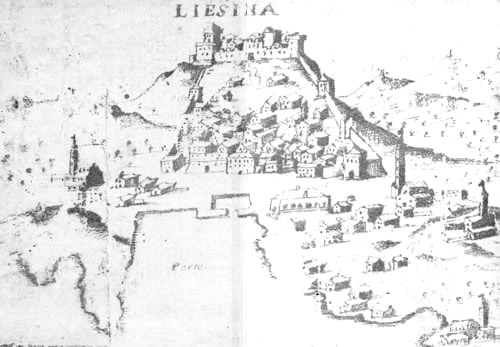
Liesina aka the town of Hvar in 1643
I have to say it’s not an easy read. Time after time I’d start in with great enthusiasm, only to get bogged down in the details and the obscure nature of the language. Yes, and there’s another thing, the statute is written, as you might expect for a medieval document on Hvar, in Latin and Venetian, with the translation into modern Croatian involving copious amounts of footnotes! So let’s start with a gentle introduction to what I’ve gleaned from it so far.
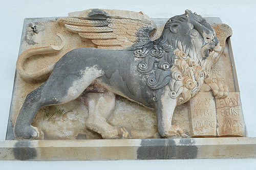
Winged lion of Venice, Hvar town
As a background, the period following the end of the Roman Empire was rather unsettled on the Dalmatian coast and the islands. There was a power struggle between the Kingdom of Hungary / Croatia, and the Venetians, who gradually took over control of the entire coast (except, of course, for Dubrovnik). As each of the various cities became Venetian communes, they were expected to draw up a formal statement of their laws and procedures. So, starting around the end of the 13th century, (Hvar became a commune in 1278) we have a wonderful collection of documents describing medieval life on the Dalmatian coast. The earliest is believed to be the Statute of Korčula – drawn up sometime before 1265, followed by Zadar (1260s), Dubrovnik ( 1272), Rab (1260s), Šibenik (late 1260s – 1293), Split (1312), Trogir (1322), Skradin (early 1300s), Brač (1305), Hvar (1331), and Pag (1433).

Statuta Communitatis Lesinae
The Statute of Hvar would appear to have been initially based on that of Brač, as they were governed by a common podestà (potestas insularum Pharae et Brachiae). Written mostly in Latin, with sections in Venetian, the Hvar statute in 1331 consisted of three books, with two further books being added in 1453 for a total of five.
Book One deals with communal offices, and the oaths to be sworn by the inhabitants and officials. Book Two covers procedural matters, breaches of private property, and inheritance / family matters, while Book Three covers the criminal law.
Book Four (from 1453) gets more interesting on definitions of land and land-use, the duties of ordinary people such as farmers, butchers and fishermen, the boundaries between the various settlements of the commune of Hvar, as well as communal roads. Book Five covers the economy (seamanship, animal husbandry, agriculture), but also such administrative matters as communal offices and bodies, taxes, etc.

Hvarski Statut
None of the original medieval manuscripts of the Hvar statute survive. Sadly, these all appear to have burned during the Ottoman attacks of 1571. Only one single copy of the manuscript by the notary Pompeo Cranco survived the attack, and this was the basis for the first printed edition in Venice in 1643. Furthermore, Cranco’s original manuscript is also now lost to us, and there is only a copy of it from 1633, held in the private archive of the Machiedo family in Hvar.
The first printed edition of the statute was published under the title Statuta Communitatis Lesinae (Venice: Marco Ginammi, 1643) and was the official law book of the Hvar commune until the fall of the Republic of Venice in 1797. Local historian Šime Ljubić took that edition as the basis for his analysis and translation into Croatian, Statuta communitatis Lesinae (Pharae), in 1882-3. The version I’ve been reading is the 1991 edition by Ivo Kasandrić and Antun Cvitanić, who have contributed their own analysis and a more modern translation – Hvarski statut. Statuta communitatis Lesinae (Pharae).
The title in 1643 was Statuta Communitatis Lesinae, as the island was known to its Venetian overlords as Lesina. The name comes from the Old Slavonic word lies, meaning wood, and liesna meaning wooded, from which we can guess that the island was much more forested back then. The land register determined how much agricultural land a person could hold, being a maximum of 30 motika per person. The current translation of motika is a hoe, but as an old unit of measure, it gives around 1.3 hectares of agricultural land, renewable every 10 years. The rent for 30 motikas of agricultural land was 1/6th of the produce, whereas building land and pasture was paid for in money.

Old vines
The main export crop of the island was wine, the production and sale of which was closely regulated by the statute. As the amount of wheat grown on the island could not sustain the population, it was necessary to export wine to buy grain for making bread. Severe penalties were put in place to prevent the export of grain, while the reverse was true of wine – it was not permitted to import that! Other crops were figs and olives. The island’s fishermen were forbidden to sell their catches elsewhere, and salted fish, especially mackerel and sardines were an important source of food as well as income. During Venetian rule, the island population went from 1,000 men fit for military service in 1525, to 6,115 total inhabitants in 1673. Hvar, it seems, was a prosperous commune. In 1774, Alberto Fortis recorded that the island had the least number of poor people, and the richest variety of products in the Adriatic, all of good quality!
The communal land was divided into sections, the boundaries of which were described using a combination of landmarks such as bays or freshwater springs, churches, stone walls and graves. Now whereas you can still find the cove of Dubovi Dol on a modern map of the island, and the church of Sv Petar still stands at the eastern end of Vrboska, you’d be hard pushed to find the position of walls and graves belonging to local people in 1453. And don’t think you can depend on the churches keeping the same names down through the years! For example Sv Illya was a small medieval church in Svirče that was later replaced by one dedicated to Sv Marija Magdalena.
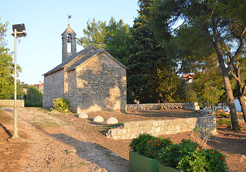
Sv Petar, Vrboska marks a medieval boundary
So what were the land divisions back then, and what relevance do they still have?
Sv Pelegrin (St Peregrine) was basically the western tip of the island, including the town of Hvar. The boundary ran from Sklačina(?) in a straight line south to the cove of Dubovi Dol and north to Maslinica bay. That’s pretty much where today’s Selca – Dubovica tunnel runs, and the main road connecting Hvar town with the rest of the island.

Venetian Loggia in Hvar town
Brda i Plaža (Mountains and beaches) covered the south-facing slopes from the boundary with Sv Pelegrin in the west, along to where it meets the fields of Plame in the east. So the boundary is described as going from the Sklačina to Dubovi Dol line, following the old road along the middle of the hills all the way to a place called Veliko Illisse, which the Slavs called Vele Zešvine, and from there south to Zadišće on the coast. Now, none of those places are familiar to me, but it seems that this area corresponds pretty well to the best Plavac vineyards, known as the Južna Plaža or South beaches.
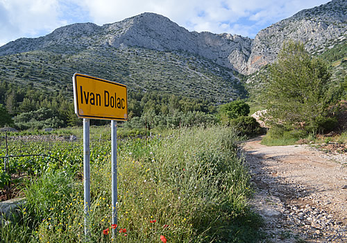
Vineyards of Ivan Dolac
Polja Sv Stjepan (Fields of St Stephen) better known as the Stari Grad Plain today, this was and is the best agricultural land on the island, indeed on any of the Dalmatian islands. In the Middle Ages a large part of the plain was owned by the Hvar bishopric, which was initially based in Stari Grad, so the land was known as Campus sancti Stephani after the patron saint of the diocese. It was bounded on the west side by Maslinica bay and the border with Sv Pelegrin. So far, so good. On the eastern side, the boundary runs from Oskorušica bay, up the hill called Šudljivac in a straight line all the way to the place called Schrivobrai Glog (really?) to the well called Sterleva, going in a straight line all the way to the church of Hum Sv. Vid (St Vitus) and on up Ravan hill to the spring of Krušvica. From there by the old way on the mountain to the Tomb of Šubić to the road to Plame, which forms the southern boundary. Aha! This explains why any maps, guides or signposts related to the Stari Grad Plain stop somewhat arbitrarily before the end of the Greek or Roman extent.

Fields of St Stephen
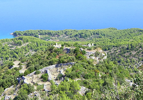
Vrbanj, one of the inland vlllages, was fairly important in medieval times, and its land included the deep bay where Vrboska now lies. Back then it was not safe to live on the coast, due to pirates and the Ottoman Turks. Vrbanj borders with the fields of St Stephen to the west, while its eastern boundary starts with the tiny church of Sv Petar in Vrbanja bay (today’s Vrboska) running direct to Mihaljina Sela, then in a straight line to the large drystone walls called Vukoslav’s Gomila and from there to Sv. Ilija (St Elijah, now the site of Sv Marija Magdalena in Svirče), up the hill called Gračišće and from there to Vela Grizica on Ravan hill and right to the previously mentioned spring in Krušvica.
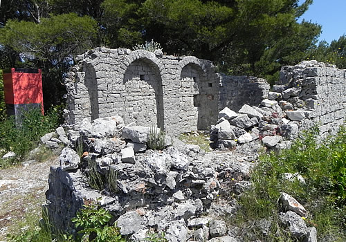
Ruins Sv Vid (St Vitus)
Pitve is another of the inland villages with an important past. Securely tucked away at the top of a valley, Pitve also had its fishing harbour, now known as Jelsa. Bounded by Vrbanj in the west, Brda i Plaža to the south, and Plame on the east side.

Jelsa, the port of Pitve
Plame occupied the long plateau of the eastern tip of the island, mainly pasture and forests, with the settlement of Sućuraj at the far end. This part actually had better connections across to the mainland than to the rest of the island. The boundary description is somewhat of a mystery to me, except for the fortress of Gališnik, the other names are not familiar: from Vela Zešvine and Zadišće southwards to the coastline northwards to the old fortress called Gališnik, then westward until Hum which lies on the west side of the bay called Milna and from there to the seashore. Everything on the eastern side belongs to Plame up to the Church of Sv. Jure (St George) which lies at the end of the island.

Plame, looking towards the mainland
It’s interesting how the old divisions still linger on in the local consciousness. They call it Campanilism in Italian, meaning the affiliation of your local belltower. So today you still hear different dialects and very different accents in those areas. The wine-growing hills still reflect the old names, for example the excellent Plame wine from Vujnovic winery in Sucuraj. many people have come and gone since 1331, but the landscape isn’t so very different. One of these days, we’ll try walking some of these boundaries, and see what we find!
Hill-fort of Galešnik
Today’s quotation
“The glorious uncertainty of the law” was a toast given by Mr. Wilbraham at a dinner of judges and counsel in Sergeant’s Inn Hall in 1756 soon after Lord Mansfield had overruled several long-established legal decisions and introduced many innovations into the practice of the court.

Vrbanj and Ravan hill from Hum Sv Vid
References
Hvarski statut. Statuta communitatis Lesinae (Pharae) 1991, digitized version
Statuta Communitatis Lesinae 1643, digitized version


You must be logged in to post a comment.