Leaving Šibenik behind us, we headed northwards up the Dalmatian coast towards Zadar, with a bit of a detour around the lovely Lake Vrana Nature Park (not to be confused with the other Lake Vrana on the island of Cres.) This is Croatia’s largest lake, and a very important stop-off for birds on their annual migration. The long flight across the Mediterranean from Africa means this is a welcome rest and feeding place. In fact some birds like it so much they build their nests and breed here!

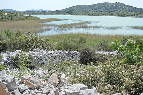
View of Lake Vrana from the boat dock
The lake lies in a flooded karst valley, very close to the sea. The surface of the lake is officially listed as 0.1 metres above sea level, but in reality that varies considerably. Technically speaking, this lake is almost entirely an cryptodepression – that is, it lies below sea level. The water in the lake is slightly salty – mostly due, they think, to leakage of minerals from the rocks, and evaporation in the hot summer months. But, in especially dry years, there’s another source of salt in the lake.

Bees busy in the flowering trees
The lake is divided from the sea only by a narrow karst ridge, between 0.8 and 2.5 km (half a mile to 1.5 miles) wide. In the 18th century, the local landlord Francis Borelli thought it would be a good idea to drain some of the extensive marshy area at the top end of the lake to create more farmland, and to reduce the malaria problem. So in 1752, they started construction on a canal to connect the lake to the sea. Opinions differed as to the viability, or even the advisability of the project, but in 1770, the canal was completed. At that point, the water level in the lake rapidly dropped 3 metres, and the resulting wave reached to Betina on the island of Murter!

Vrana map from the 18th century, showing the extensive marshland
Since then, the Prosika canal has been widened and deepened further, in order to maintain the farmland. Most of the time, water flows outwards from the lake to the sea, as planned. However, in drought years, when the lake is much lower than usual, the flow reverses, and the lake and its protected nature reserve receive a hefty dose of salty sea water. It’s a problem that I can only think will happen more often, given the rising sea levels.

Prosika boat dock, and the entrance to the canal
We started our tour of the lake at the Prosika canal. There’s a lovely little boat dock and a view down the peaceful lake. In May, it’s very quiet, and we have the place to ourselves. Across the water to our right is Babin škoj – but “Grandmother’s island” is now a peninsula. From here we can see the defensive walls – a double line of walls built by the Illyrians, and a single line all around built by the Romans.

Babin škoj
Babin škoj has been inhabited for about 4,000 years. As an island, it was an ideal place to retreat to at night, taking all your livestock with you. Those original residents built a double line of walls across the end of the island facing the shore – very clear from a distance, but looking like a simple heap of stones from close to!

Illyrian defensive wall
Later, the Romans also appreciated the island as a refuge. They built a wall all around it, as presumably they were also at risk of being attacked by boat!
Roman wall
For the Venetians in the 16th century, Babin škoj was not so much a refuge as a frontier post. Until 1699, the border between the serene Republic and the Ottoman Empire went right through the middle of the lake. This defensive tower would have been one of many that lined the lake shore, bristling with guns and other weaponry.

Venetian tower
Round the south end of the lake, we bounced along the rough stony tracks to try and find one of the ornithological stations on the east shore. The paths are not well signed, though, and didn’t exactly match the ones on our map which made navigation a tad tricky! After back-tracking a couple of times, we decided we’d just give that shore a miss, and headed upwards and onwards.
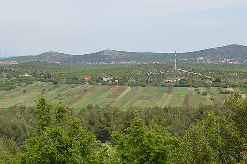
View over the nearby farmland
In the Middle Ages, Vrana was far from being the sleepy little backwater it now appears. It was nicely positioned in the centre of the important royal towns of the old Croatian state – Nin, Biograd, Knin and Šibenik. This was where it was all happening – today’s capital of Zagreb was merely a small merchant town back then. Croatian nobles had estates in this area, and the Benedictine Abbey of St Gregory was founded in the 9th century. The Insignia of the Croatian Kingdom was held there for many years.

Vrana castle walls
In 1076, the newly crowned King Zvonimir donated the monastery to Pope Gregory VII, together with all its income, treasury, valuable gospels, etc as a “hospitium” for the Papal legates. Then the place was granted to the Knights Templar. They turned the monastery into a castle, with a large oblong courtyard, towers and a moat, with a second walled court around the old monastery. The Archbishop of Zara (Zadar) in 1163 tried to claim jurisdiction, but the Templars maintained they were responsible only to the supreme pontiff –and Pope Alexander III agreed. But however powerful the Templars were at their height, by 1311 the entire order was suppressed by the Council of Vienne in France. In Dalmatia, as elsewhere, their property was forfeit and Vrana castle was given to the Knights Hospitaller.

Vrana castle interior
The time of the Knights Hospitaller turned out to be quite dramatic. The most famous of the priors was Count Ivan Paližna, who was a conspirator in the plot to put Charles III of Naples on the Hungarian throne. In 1383, Queen Maria and her mother Elizabeth visited Vrana castle, a bad move. Taken prisoner, they were removed to Novigrad where Elizabeth was murdered, and Maria held until the Venetians forced her release in 1387. Paližna, now beseiged in Vrana castle, asked Tvrtko, King of Bosnia for his help. Over the next couple of years, Paližna and Tvrtko took on Sigismund’s army, and ended up taking control of Dalmatia (except for Zadar and Dubrovnik). At the height of their power, both commanders died and in 1392 the priory of Vrana was suppressed by Vuk Vucich, the Ban of Bosnia. The last Hospitaller prior was thrown into prison.

Vrana castle – exterior wall
Vrana was sold to the Venetians in 1409, and they held it until 1538, when it was surrendered to the Turks after the fall of Klis. The Venetians retook the castle during the Candian war (1645-1669), but didn’t want to garrison it so they destroyed it. Completely trashed it. And after that the castle was never rebuilt.

Pagano map – showing Castle Vrana in 1525
It’s a little hard to see what’s what, given all the trees that are taking over. Here’s the impressions of another traveller, British architect Sir Thomas Graham Jackson, who visited in 1887, and sketched the castle ruins:

Sketch of the castle by Jackson
“The castle is a stupendous heap of ruins covering a very large extent of ground on the summit of a natural elevation. It was a very regular building, consisting of two rectangular courts divided by a central wall, and surrounded by a deep fosse, excavated for the most part in the solid rock. Notwithstanding the enormous strength of the masonry the whole now lies in utter ruin and never was an ancient castle more thoroughly ‘slighted’. In one corner of the first courtyard is pointed out the site and few remains of the church of S Gregorio, but one looks in vain for the great hall, on whose walls were hung the knightly shields and cuirasses of the brotherhood, whose four windows recorded in their rich storied panes the feats of the order, and within which was concerted the conspiracy for overthrowing two queens and placing Carlo of Durazzo on the throne of Hungary.”
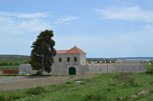
Turkish Han
During the Turkish period, Yusuf Mašković, a local peasant, rose to become an important advisor and commander of the Turkish fleet. He intended to retire to Vrana, and in 1644 sent funds to have a large Han built – partly to accommodate travellers, and partly as his own home. Sadly, he never made it as the Sultan had him executed for showing mercy to Venetian prisoners. The unfinished Maškovića Han just sat there for several centuries, until a recent grant from the EU enabled work to restart! It’s an impressive building, unfortunately not open at the time of our visit, but apparently planned to open as a hotel/hostel sometime in the future. Wouldn’t that be a great place to stay? UPDATE: We visited Mašković again in October 2022, and stayed there!

Back wall of the restored Han
Here’s a description of it by a much earlier tourist who did see inside – Abbe Alberto Fortis, who visited in the 1770s (his book Travels into Dalmatia was published 1774) “This castle is now a frightful heap of ruins, reduced to that state by the Venetians. The Han, that stands near these ancient walls, is well worthy of observation, although it is also in a ruinous state, being abandoned to the barbarity of the Morlachi, who inhabit the neighbouring lands and carry off whatever materials suit them, to be employed in their miserable cottages. The foundation of Hans, or Caravanseras, do great honour to the Turkish nation and they are very numerous throughout the Empire. This near Vrana, has been raised at a considerable expense – the front of it is about 150 feet, and its depth 175 feet; it is all built of marble, well polished, and connected; and the pieces seem to have been brought thither from the ruins of some ancient Roman fabrick; at least, on examining them, there is a reason to think so. The body of the Han is divided into two large courts, surrounded by neat decorated chambers, and well-contrived galleries; the architecture of the gates is in a bad Turkish taste, inclining to the Gothick. A part of the walls, and floors of this building, have been demolished through a foolish search for treasures.”

Front entrance to the Han
And the good Abbe goes on to describe the former water-gardens “The name of Vrana is now transferred to a wretched village that stands about a mile from the ruins of the castle, in the very place where the eminent Turk of the last age, called Hali-Beg, had his gardens; and the squalid habitation of the Curate of the parish, still goes by the name of Hali-Beg’s gardens. A manuscript now in my possession, contains a description of the water-works in these gardens, and of the then well-cultivated fields. What changes since that period! The gardens of Hali-Beg are reduced to heaps of rubbish; and the waters that were formerly conducted by art, to adorn and refresh them, now run in disorderly streams, mixing with many others, which a hundred years ago were also formed into artificial channels, and conveyed into the lake.”

Vrana under Ottoman rule, 17th century
Aside from his rather patronising attitude to the locals, it’s fascinating to get a view of the place from someone who was there a mere 100 years after it was all thriving and cultivated. Beyond the castle is Pećina cave, with its freshwater spring that was also the source of the Roman aquaduct which supplied Zadar and all the surrounding villa rusticae.

Pećina cave
It’s a pretty cave, and delightfully cool on a hot day. The signposts indicate hiking trails that continue on uphill, which could be nice to follow one day.

Cool spring
Down at the lakeside is a wetland area with trails and birding hides. The top end of the lake was first declared a Special ornothological reserve in 1983, and entire lake with surrounding wetlands declared a nature park in 1999 – around 57 km2 in total. This northwest end, in particular is what’s left of the vast (10 times bigger) Vransko blato (Mud of Vrana), once a marsh, now farmland.

Vrana Lake Nature Park map
In early May we found the trails near the lake to be knee-deep in water – fine for the birds, but not so good for us! The only section we could visit was the part with raised walkways and a ranger station – complete with resident swallow family nesting under the roof.

Resident swallow at the ranger station
Lake Vrana reserve is on the list of Important Bird and Biodiversity Areas (IBA) in Europe. A great variety of birds have been recorded here – 256 species at the last count. Some are migratory, others, such as the purple heron and pygmy cormorant, actually nest there, along with 100 other species of birds. The park is a crucial resting and feeding area for a number of European endangered species. More than 100,000 waterbirds regularly winter here. Along with the Neretva Delta, this is the largest wetland area on the eastern coast of the Adriatic Sea, providing a variety of habitats such as marshes, flooded meadows and reed beds, as well as the largest area open water.
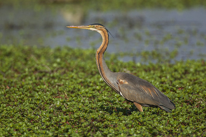
Purple Heron, courtesy of Wikimedia Commons
Based on their research, birds from all over Central, Northern and Eastern Europe stop over here. In the autumn, after resting and feeding on Lake Vrana, the birds continue southwards in three main pathways. Westwards around the Adriatic Sea and across Northern Italy, along the Mediterranean coast and down to Africa via Gibraltar. Directly over the Adriatic, crossing Italy and onwards via Southern Italy, Sicily, Corsica or Sardinia, and on over the Mediterranean. And southeastwards down the Adriatic coast and across the Balkans towards Asia Minor and the Middle East. Long, perilous journeys!
And today, my sketches are from the boat dock

My sketch of the boat dock
and Vrana castle – my version, not as detailed as Thomas Graham Jackson’s!
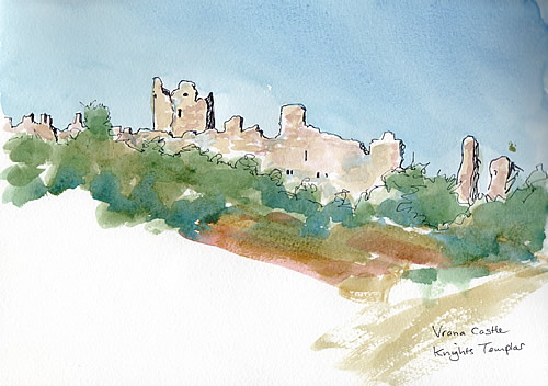
My sketch of Vrana castle
Find out more…
Lake Vrana Nature Park on facebook: www.facebook.com/vranskojezero
Vransko Jezero Park Prirode: www.pp-vransko-jezero.hr/hr/ – (Croatian only)
Dinarides Parks page on Lake Vrana: www.parksdinarides.org/en/croatia/vrana-lake?details
Birdlife International IBA assessment: www.birdlife.org/datazone/sitefactsheet.php?id=3606
Secret Dalmatia blog: secretdalmatia.wordpress.com/2009/09/01/the-medieval-fair-in-vrana-the-return-of-the-templars/


You must be logged in to post a comment.