I mentioned in a previous article that the winds have names here. And as we’re into winter now, I thought I’d take a more in-depth look at that powerful force – the bura. Now, not all buras are created equal. In local speak – there is the light bura which clears the air and cools you down a bit, and then there’s the dark bura. For that, tunnels are closed to traffic, ferries cancelled and everyone stocks up and huddles inside. The closing of the Sveti Rok tunnel during a bura I found amazing – aren’t cars safe in a tunnel, for heavens sake? Well yes, but once the cars pop out of the tunnel on the seaward face of the mountain, they’re liable to be blown right off the road!
A light bura is caused by the standard weather pattern – high pressure over central Europe and an anti-cyclone passing over the Adriatic from west to east drags down cold air from the continent. It will usually follow a warm stormy jugo (southerly) and a maestral from the west. This kind of bura will clear the air and reset the temperature. It’s fairly typical and quite a relief at the end of a hot summer. From the west side, you might see cloud caps on the mountain tops, which dissipate as the air falls.

Bura conditions
A dark bura, or black bura, on the other hand, is characterised by heavy clouds carrying freezing rain and snow. It’s set up by a high-pressure build-up of freezing air on the continental plateau, a cyclonic air system and low-pressure warmer air over the Adriatic. The coastal mountains contain the mass of air so far, but as it builds up, especially with the temperature and density drop overnight, at some point the air will pass over the mountains and fall rapidly down the slope to the sea. That’s about a 4,000 foot drop, not enough to warm the air, so as it reaches sea-level, the bura is travelling very fast and is freezing cold! It’ll scour landscapes, freeze seawater, whip up salt spray across the sea, push boats out of harbour, turn over cars, lorries and vans, sway bridges and howl deafeningly! The technical term for this is katabatic wind – i.e. a mass of air moving downhill. Other examples around the planet would be in the Antarctic, Canada, and the Froehn wind of the Alps.
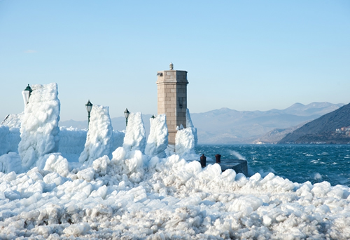
Frozen sea-spray builds up on the Senj waterfront, February 2012
The worst buras happen in the north Adriatic, around the Velebit mountain range. In particular, the town of Senj comes in for some seriously bad weather in winter, due to its location below a mountain pass. In February of 2012, the shoreline froze as temperatures plummeted to -14 degrees C with waves of 7 metres.
Heading southwards, the coastal road between the aforementioned Sveti Rok tunnel and Zadar is protected by high walls to try and keep the traffic running. That particular stretch of road holds the record of a howling 304 km/hr as measured in December of 2003! Further south, Split and Omiš can be pretty bad, again because of the dip in the mountains behind them. On the islands, the whole effect is mitigated, especially for those not parallel to the coast and therefore missing the full brunt. So, Hvar may get some snow in a bad bura, but it won’t last for long and you won’t see frozen sea-spray decorating the harbour walls, as happened in Senj.
Some local sayings about the bura
On Hvar, I’ve heard it said with authority that a “bura blows for an odd number of days“. Now I don’t have a long enough experience to judge, and I haven’t seen anything in the scientific literature that would support it.
The bura has “gone for lunch” is a lovely phrase, possibly because the wind tends to drop around midday when everything is warmer, relatively speaking.
“Bura says when I sail, you don’t” seems to be a sensible view, given that a bura can reach hurricane strength, and create some some pretty big waves out on the open sea.
And as a final thought – it’s been calculated that if the coastal mountains were around 1,000 metres higher, the bura would be a warm wind at sea level, as the air warms up at a rate of 1°C for every 100 metres it falls!
Further reading:
Wikipedia article on katabatic winds
Winds of the World: www.weatheronline.co.uk/reports/wind/The-Bora.htm


Reblogged this on thesurvivalplaceblog.
Pingback: The Winds Have Names « Go Hvar